
|


 |
NOAA Polar-orbiting Operational Environmental Satellites (POES) are three-axis-stabilized spacecrafts that are launched into an orbit 830-870 kilometers high, constantly circling the Earth in an almost north-south orbit, passing close to both poles. POES satellites from NOAA-6 offer 4 or 5 channel multispectral daily repetitive global coverage. |
| Image provided by: National Climatic Data Center |
The NOAA-12 -14 belong to the TIROS series known as the advanced Television Infrared Observing System satellite (The first meteorological satellite was one of the TIROS family).
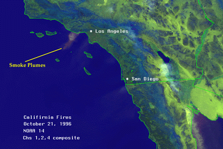
Image provided by: NOAA Satellite Active Archive
They operate as a pair to ensure that data for any region of the Earth is no more than six hours old. More than 16,000 global measurements are sent daily to NOAA's Command and Data Acquisition areas and are used for forecasting models. Additional capabilities of these satellites include fire plume detection (above) and sea surface temperatures (image below).
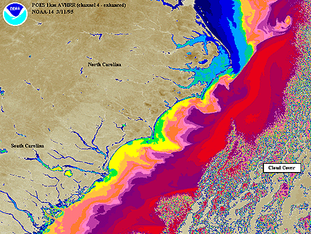
Image provided by: NOAA Satellite Active Archive
NOAA's POES satellites continue to carry the
Advanced Very High Resolution Radiometer (AVHRR)
which is a four or five channel scanner (depending on the model).
AVHRR data are acquired in three formats:
| High Resolution Picture Transmission (HRPT)
Full resolution (1.1 km) image data transmitted to a ground station as they are collected. Local Area Coverage (LAC)
Global Area Coverage (GAC)
|
A new series of polar orbiters, with improved sensors, will began with the launch of NOAA-k (NOAA-15) in early 1998.
Text Provided By: NOAA Polar Orbiter Data User's Guide.
|
dmsp poes |
|
Image Interpretation |