
|


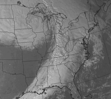
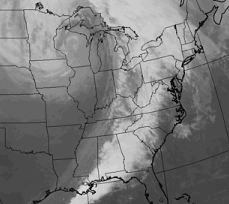
Images (a) and (b) are examples of visible and infrared satellite images respectively (valid for the same time).
|
Visible images measure scattered light and the example here depicts a wide line of clouds stretching across the southeastern United States and then northward into Ontario and Quebec. | |
|
In contrast, infrared images are related to brightness. Therefore, the clouds over Louisiana, Mississippi, and western Tennessee in image (a) appear gray in the infrared image (b) because of they are lower and have relatively warm cloud tops. The warmer the temperature, the lower the clouds, the darker the color. |
From Alabama northeastward into New York is a region of deep convective clouds that appear bright white in both pictures. Because of their higher cloud tops, these clouds are bright white in both images because of their high reflectivity and extremely cold cloud top temperatures.
The clouds in Canada probably high thinner cirrus and cirrostratus clouds. They have lower reflectivities and therefore appear somewhat darker in the visible image (a) but because of their higher altitudes and colder cloud tops, they appear bright white in the infrared image (b).
|
infrared (ir) |
|
color enhanced ir |