
|


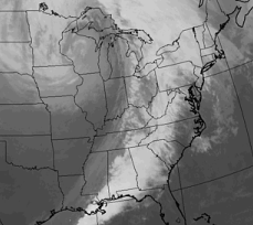
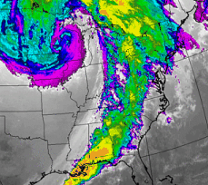
Images (a) and (b) are examples of gray scale and color enhanced infrared satellite images respectively (valid for the same time).
|
In this infrared image (a), the thunderstorms erupting from the Gulf of Mexico into New York appear to be roughly the same height. |
|
Color enhancement is a procedure where specified levels of energy -- in this example, infrared energy -- are given a specific color. this makes locations with the desired energies easier to locate. In this example (b), shades of yellow and orange represent infrared energy emissions consistent with strong thunderstorms. This is because infrared energy is proportional to brightness temperature, and the highest cloud tops are colder than those at lower altitudes (the highest cloud tops are typically associated with the strongest thunderstorms). |
These images have been extracted from the same data, however color enhancement uses colors ranging from purple to red to make certain features stand out. Such features are not as easily observed in gray scale images.
|
vis -vs- ir |
|
water vapor (wv) |