
|


Infrared satellite measurements are related to the brightness temperature. For an infrared picture, warmer objects appear darker than colder objects, as in the example below (a composite of data from GOES-8 and GOES-10 satellites).
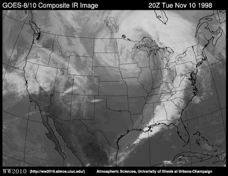
Since temperature in the troposphere decreases with height,
high level clouds are colder than
low level clouds.
Therefore, low clouds
(like those found over North Carolina and Virginia)
appear darker on an infrared image and
higher clouds
(like those found throughout the eastern U.S.) appear brighter.
The very dark shades of gray in parts of the Rocky Mountains
and in the deserts of the Southwest indicate regions
where the ground is being heated by the sun.
|
visible (vis) |
|
vis -vs- ir |