
|


To understand Doppler radial velocity patterns, one first has to consider the geometry of a radar scan. Normally the radar beam is pointed at an elevation angle greater than zero so that the beam, as it moves away from the radar, moves higher and higher above the surface of the earth. Because of this geometry, radar returns originating from targets near the radar represent the low-level wind field, while returns from distant targets represent the wind field at higher levels.
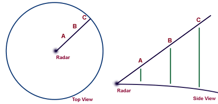
On a radar PPI display, the distance away from the radar at the center of the display represents both a change in horizontal distance and a change in vertical distance. To determine the wind field at a particular elevation above the radar, one must examine the radial velocities on a ring at a fixed distance from the radar. The exact elevation represented by a particular ring depends upon the elevation angle of the radar beam.
In the examples below, idealized Doppler radial velocity patterns were constructed with a computer assuming simple vertical wind field patterns. These simplified radial velocity patterns can help us understand the more complicated patterns that are associated with storm motions. Doppler velocity patterns (right) correspond to vertical wind profiles (left), where the wind barbs indicate wind speed and direction from the ground up to 24,000 feet. Negative Doppler velocities (blue-green) are toward the radar and positive (yellow-red) are away. The radar location is at the center of the display.
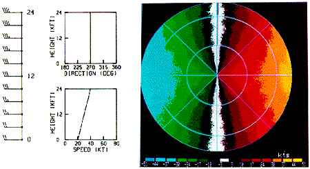
Image by: Brown & Wood
For this first example, wind direction is constant with height, but wind speed increases from 20 knots at the ground to 40 knots at 24,000 feet. Note on the radial velocity field that the maximum inbound velocity is to the west and maximum outbound to the east while to the north and south the radar measures zero radial velocity. This is because the winds are perpendicular to the radar beam when viewed to the north or south.
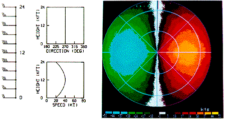
Image by: Brown & Wood
In the second example, the winds increase from 20 to 40 knots between zero and 12,000 feet and then decrease again to 20 knots at 24,000 feet. The wind direction again is constant. The radar beam intersects the 12,000 foot level along a ring half-way across the radar display. This is where we see the maximum inbound and outbound velocities.
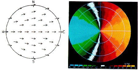
Image by: Brown & Wood
In the third example, we see a wind field which changes direction from north to south but has a constant speed at all heights. The zero radial velocity line now bends so that it is everywhere perpendicular to the wind field. The maximum radial velocities are observed where the radar beam points directly toward or away from the wind direction.
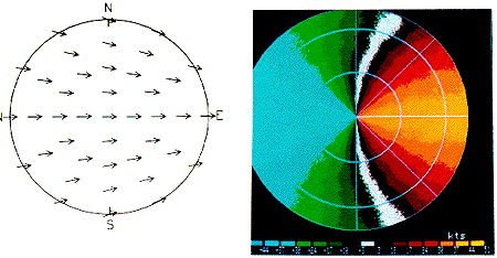
Image by: Brown & Wood
In our fourth example, we see the same effect but in this case, the flow is confluent instead of difluent.
|
Imagery |
|
directional shear |