
|


This is a horizontal, low-level cross-section of a "classic" supercell. The storm is characterized by a large precipitation area on radar, and a pendant or hook-shaped echo wrapping cyclonically around the updraft area. Note the position of the updraft and the gust front wave. The intense updraft suspends precipitation particles above it, with rain and hail eventually blown off of the updraft summit and downwind by the strong winds aloft. Updraft rotation results in the gust front wave, with warm surface air supplying a continual feed of moisture to the storm.
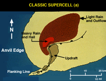
Updraft rotation occurs when winds through the troposphere are moderate to strong, and low-level turning is significant. As inflow air in the lowest 1-3 kilometers approaches the storm from the south or southwest, the low level turning results in the development of rotation about a horizontal axis. As the air is lifted into the updraft, the rotation is "tilted" to that about a vertical axis. To see this rotation about a horizontal axis caused by wind shear, imagine rolling a tube along a table-top with the palm of your hand.
The movement of your hand represents the strong winds above the surface, producing rotation because the winds near the ground are much weaker. This simple picture is complicated by the turning of the wind direction with height, but the concept remains similar. Lifting this "horizontal" vortex into the updraft results in cyclonic rotation.
A westward view of the classic supercell reveals the wall cloud beneath the intense updraft core and an inflow tail cloud on the rainy downdraft side of the wall cloud. Wall clouds tend to develop beneath the north side of the supercell rain-free base, although other configurations occur.
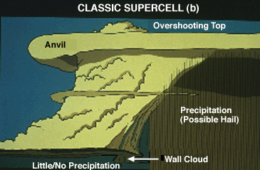
Observe the nearly vertical, "vaulted" appearance of the cloud boundary on the north side of the Cb and adjacent to the visible precipitation area. A sharp demarcation between downdraft and rotating updraft results in this appearance. Note the anvil overhang on the upwind (southwest) side of the storm and the overshooting top, both visual clues as to the intensity of the updraft.
|
on radar |
|
Features |