
|


Looking east from about 40 miles away, we see a line of towering cumulus clouds and a large supercell storm in the background. Note the great amount of anvil overhang and the large overshooting dome at the summit of the updraft.
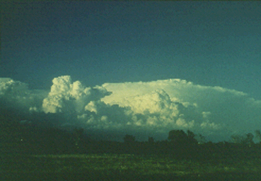
Photograph by: Doswell
Distant supercells frequently have this domed, "diffluent" anvil appearance, with the supercell's tremendous updraft velocities and outflow resulting in marked upper-level divergence. The visual clues are strong, although we cannot be sure that this is a supercell simply from appearance. By necessity, man and machine (i.e., spotters and radar) complement each other in the severe weather detection program. This storm produced hail but no known tornadoes in eastern Oklahoma.
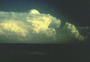
Photograph by: Bluestein
This supercell featured a rock-hard, overshooting Cb top and anvil overhang, looking southeast from about 40 miles away. Note that the supercell Cb is more vertically oriented than the weaker updraft of the neighboring towering cumulus cloud. This is a valuable clue in estimating the strength of updrafts on a day with strong vertical wind shear. This storm produced baseball hail, but no known tornadoes, along a track in southeast Oklahoma and southwest Arkansas.
|
Supercells |
|
rotating updrafts |