
|


A westward view of a composite HP storm model shows the position of an inflow cloud band, very similar to the previously mentioned beaver's tail cloud in the classic supercell. In fact, the HP storm has an appearance similar to the classic supercell, except for the opaque precipitation curtain wrapping around the west and southwest flanks of the wall cloud and/or updraft.
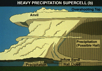
Sometimes the precipitation is a solid visual curtain, and at other times there is a distinct break, shown here, between the precipitation falling from the anvil area and that descending from the southwest flank. The southwest flank precipitation shaft is often visually dark and blue-green in color, indicative of unusually heavy rain and hail.
Photograph by: Neiman
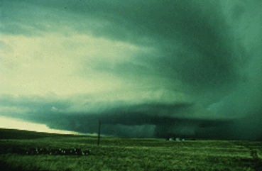
This is a westward view of an HP storm in extreme northeast Colorado. Cyclonically-curving inflow bands are visible in the upper portions of the photo, feeding into the updraft area. The storm had a very well-developed wall cloud, with precipitation wrapping around the north, west, and southwest flanks of the lowered cloud base. Note the subtle gust front and shelf cloud extending southward from the wall cloud.
Spotters will have a difficult time with the HP supercell, since there can be poor visual contrast between the wall cloud and precipitation behind it. The strongest visual clues in identifying this type of supercell usually are the curving inflow bands and mid-level cloud bands which wrap around the updraft, both suggestive of storm-scale rotation. This dramatic storm produced large hail but no known tornadoes.
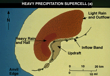
This is a low-level, horizontal cross section through a wet or heavy precipitation (HP) supercell. Basically, the HP supercell has a broad hook or pendant, usually with high radar reflectivities (VIP 5s or 6s). Occasionally, the HP supercell has an even more pronounced southwest flank precipitation area, with the radar echo taking the shape of a kidney bean or letter "C".
The inflow/rotating updraft notch will face east, and with nearly equal size precipitation areas northwest and southwest of the mesocyclone. Whichever is the case, the rotating updraft is on the leading storm flank, with heavy precipitation falling into the west and southwest flanks of the mesocyclone. Note the inflow band in the vicinity of the pseudo-warm front east of the updraft.
|
characteristics |
|
flow field |