
|


In this photograph, the typical HP storm visual appearance is present: beaver's tail inflow bands curling into the front-flank updraft, a gray area of anvil precipitation to the north, and a dark rain and hail core to the southwest, falling from what earlier had been the rain-free base.
Photograph by: Doswell
In the HP stage, this storm produced large hail, gusty winds, and extremely heavy rainfall, as well as several funnel clouds. One of these is visible where the inflow bands intersect the updraft. Continuous lightning occurred with this storm, much of it in-cloud, but a sizable percentage being cloud-to-ground strikes. Indeed, HP supercells seem to be especially prolific producers of lightning.
Photograph by: McGinley
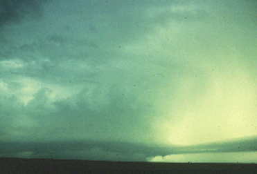
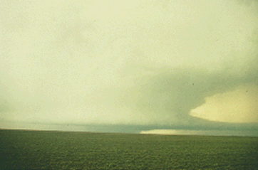
Another HP supercell is pictured in the distant west. The characteristic inflow bands are present in front of a translucent, anvil-born precipitation area on the extreme right. Note the rotating, vaulted Cb adjacent to the anvil precipitation, and the dark precipitation shaft in the left-center, emanating from an area that would be visually rain-free in a classic supercell. This storm produced a 1/2 mile wide tornado shortly before this time. It later produced several smaller and weaker tornadoes. Many times when a tornado does form from an HP supercell, the southwest flank precipitation area literally wraps around the tornado, obscuring it from view.
|
Supercells |
|
characteristics |