
|


Supercell storms come in different shapes and sizes, as observed on radar and by the human eye. Some are very prolific precipitation producers, whereas others produce very little precipitation that reaches the ground.
Photograph by: Moller
This is a westward view of a high precipitation (HP) supercell approaching in the evening light.
Photograph by: Moller |
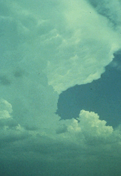
Hard, cumuliform anvil overhang, a vertical Cb edge, and flanking line are all visible in this southeastward view of a supercell storm. Mammatus can be seen on the underside of the north Texas supercell. Golf ball size hail, downbursts, flash flooding, and rotating wall clouds occurred without any known tornadoes. |
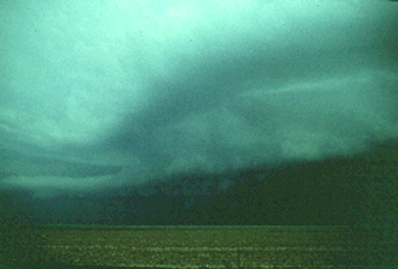
This slide shows the problem that frequently arises in viewing a tornadic storm to the north -- lack of contrast. The dark precipitation area all too often blends in with wall clouds, tornadoes, etc. However, important clues as to the nature of this particular storm are visible, including the circular, mid-level cloud bands we saw in an earlier storm. These bands suggest rotation, and this storm did produce at least one tornado.
Photograph by: Moller
Also note the flat, elongated cloud on the right side of this photo. This is another type of "tail cloud," with the appearance of a beaver's tail. The east-west oriented cloud frequently is seen in the vicinity of the stationary gust front or "pseudo-warm front," which is northeast of the rotating updraft. The "beaver's tail" usually is at rain-free base level, slightly higher than the tail cloud associated with a wall cloud. Storm chase veterans consider these clues to be strong evidence of a supercell and suggestive of possible tornado formation, although not every tornadic supercell has pronounced mid-level rotating cloud bands and inflowing tail clouds.
|
Features |
|
HP Supercells |