
|


There are ample signatures of updraft rotation in this hazy, northeastward view of a very intense supercell from 40 miles away. The circular mid-level cloud bands and the smooth, cylindrical Cb strongly hint of updraft rotation. Above the mid-level cloud band, an extremely hard Cb top is barely visible (upper right) towering into the anvil. Note the smooth, "laminar" flanking line on the extreme left. A strong, "capping" temperature inversion in the low levels probably accounted for the laminar appearance of the flank.
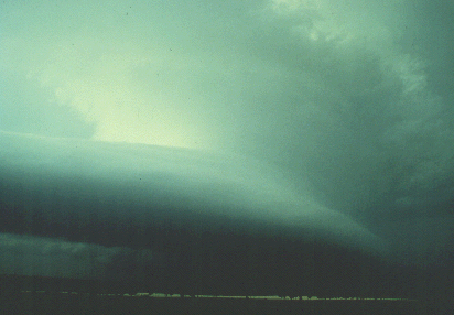
Photograph by: Doswell
Cloud elements moved along the flank into the main Cb, with rapid vertical development occurring at the merger point. Close examination of the photo will reveal a wall cloud beneath the lower left edge of the Cb, with a relatively bright "clear slot" ahead of the wall cloud. Within 20 minutes, the storm produced two significant tornadoes near Alfalfa, Oklahoma.
Photograph by: NSSL
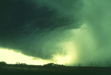
A close, westward view of a supercell updraft and adjacent precipitation cascade strikingly resembles the model we have just seen. Wall clouds frequently slope downward towards the precipitation area, as shown. If you are a mobile spotter and encounter a view such as this, turn around and out-run the storm by going eastward or, better yet, move away from the storm to the southeast. This is very close to the fall area of large hailstones, and moving north or waiting at this location will put you in danger from large hail and tornadic winds.
|
overshooting tops |
|
backlighting |