
|


Multicell line storms consist of a line of storms with a continuous, well developed gust front at the leading edge of the line. An approaching multicell line often appears as a dark bank of clouds covering the western horizon. The great number of closely-spaced updraft/downdraft couplets qualifies this complex as multicellular, although storm structure is quite different from that of the multicell cluster storm.
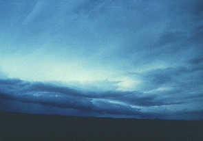
Photograph by: Doswell |
Multicell line storms are better known as squall lines, which is the term that we will use from here on. The former name is for positioning squall lines in the thunderstorm spectrum. |
Squall lines most frequently produce severe weather near the updraft/downdraft interface at the storm's leading edge. Downburst winds are the main threat, although hail as large as golf balls and gustnadoes can occur. Flash floods occasionally occur when the squall line decelerates or even becomes stationary, with thunderstorms moving parallel to the line and repeatedly across the same area.
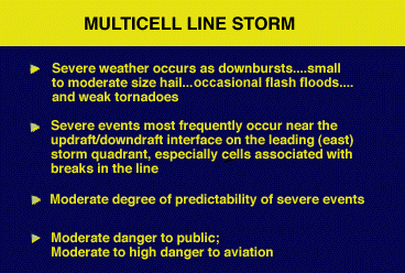
Squall lines with a confirmed severe weather history allow for the issuance of reliable warnings. Pilots should be extremely cautious, as they should for all thunderstorms, particularly near the squall line's leading updraft/downdraft interface.
|
Multicell Clusters |
|
components |