
|


This particular storm evolved from a supercell into a short line of storms at the time of the photograph. We are looking west from about 5 miles, as the storm approached. Wind damage and large amounts of small hail were occurring within the squall line at this time.

Photograph by: Moller
The squall line is a solid or broken line of thunderstorms with a continuous, well-developed gust front on the leading edge. Thus, updrafts and new updraft development occur on the downwind (east) side, where the squall line is moving into unstable inflow air. The gust front lifts warm moist air into the updraft, and the cool downdraft lowers mid-level air to the ground. Squall lines are common, especially in vertically sheared environments where the mid-level winds are moderate to strong.
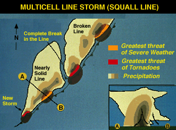
The most common severe weather element in squall lines, by far, is the downburst, with damaging winds possible from the time of gust front passage, into the period of heavy precipitation. Hail may occur with the rain, with the heaviest rain and largest hail adjacent to the updraft. Dissipating elements at the rear of the squall line often result in a period of light rain before cessation of precipitation.
Intense storms, in rare cases even tornadic supercells, periodically occur in squall lines. The most likely locations for these more powerful storms are at an eastward bend, on the south end, or north of a significant break in the line. Note that all of these positions allow a storm to compete better with its neighbors for the low-level inflow air.
|
introduction |
|
on satellite images |