
|


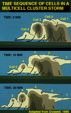
This illustration portrays a portion of the life cycle of a multicell storm. As cell 1 dissipates at time = 0, cell 2 matures and becomes briefly dominant. Cell 2 drops its heaviest precipitation about 10 minutes later as cell 3 strengthens, and so on.
|
Thus, severe multicell storms
characteristically produce a brief period of hail and/or downburst damage
during and immediately after the strongest updraft stage. Later updraft
resurgence may or may not result in further damage, leading to a spotty damage
pattern.
If the winds in the storm environment are blowing from left to right, it can happen that the storm motion arising from new cell development nearly cancels the motion arising from the environmental winds. Thus, new cells reach maturity over the same location, repeatedly. |
This is the train-echo pattern of flash flood producing rainfall, although train echoes also may occur as different multicell thunderstorm complexes moving across an area with a greater time interval. Not having the benefit of radar, it will seem to citizens living in an area receiving repeated, short-term precipitation bursts that the storm is backing up and moving across again and again. This is a popular but erroneous notion.
A closer view at T = 20 minutes (from in the above slide) shows that cell 3 still has the highest top, but precipitation is undercutting the updraft in the lower levels. New echo development is occurring aloft in cells 4 and 5 in the flanking line, with only light rain falling from the dissipating cells 1 and 2 on the northeast side of the storm cluster.
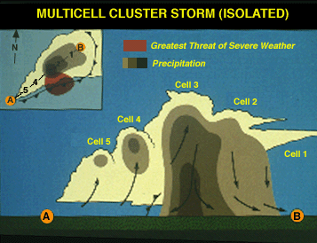
The inset shows what the low-level PPI radar presentation might look like. This storm appears to be unicellular but the several distinct echo tops tell us otherwise. Note that the greatest risk of severe weather at this time extends from beneath the heavy precipitation areas of cell 3 (hail and downbursts) into the area of the leading gust front (downbursts and, on rare occasions, weak gust front tornadoes or gustnadoes).

Photograph by: Moller
Here is a real storm, with radar superimposed. Observe the physical similarities to the second slide. This Texas Panhandle storm was non-severe. Looking north-northeast from about 20 miles. Note that the updraft numbering is reversed.
|
perspectives |
|
evolving storm |