
|


...About 15 minutes later, we have moved off to the east, but the storm is closer (relative to the photographic position) than before, about 4 miles to the west. The storm (below) was showing a dramatic visual increase in an opaque precipitation curtain northeastof the updraft at this time, which was verified by a much larger and more intense radar echo.

Photograph by: Moller
Note that the precipitation curtain extends fully around the back side of the vaulted updraft and the wall cloud lowering. From this position closer to the updraft, the easterly inflow has increased to 40 to 50 MPH! Not only was there strong inflow, it was becoming progressively stronger as it was "squeezed" into the mesocyclone. The radical increase in inflow, the increase in liquid (and likely frozen) precipitation, and the ominous appearance of the rotating storm led to an inescapable conclusion, that a tornado is about to form.
Photograph by: Moller
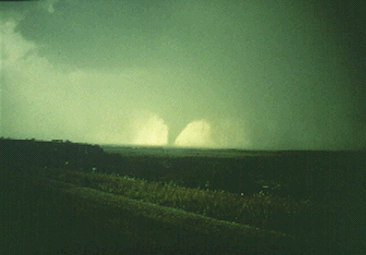
The tornado was buried in rotating rain curtains, but the rapidly-moving precipitation parted long enough to give the storm chasers this northwest view from about 3 miles. After about 6 minutes, the tornado became embedded in rain again, as it continued along a 20 mile path of destruction.
The parent storm had mainly LP traits early, then in quick succession swung into classic and finally HP storm modes. Clearly, these "variations" are spin-offs of one general storm classification, the supercell: the most dangerous of thunderstorms no matter which of the radar or visual appearances it assumes.
|
intensifying storm |
|
Cyclic Storms |