
|


Looking northwest from above, an artist's view of a cyclic supercell portrays the rope stage of the dissipating tornado, and the rapidly weakening updraft (A) associated with it. At the same time, a new rotating updraft (B) is developing several miles to the east along the intersection of the RFD gust front and the stationary front (referred to as a pseudo-warm front). The juxtaposition of the intersecting gust fronts make this a highly favored area for formation of a new rotating updraft.
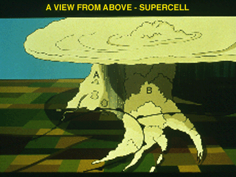
The clear slot knifing between (A) and (B) and the new overshooting top indicates that (B) is now the dominant updraft. The cyclonically curving cloud bands inflowing to (B) and a "beaver's tail" oriented east-west in the cloud shadows near the pseudo-warm front are important visual supercell signatures that spotters are likely to observe.
From a meteorological view, as the cool and warm air on adjacent sides of the pseudo-warm front rush westward into the mesocyclone, there is a tendency for the north side cool air to slide beneath the warm air, which, in turn, rotates above the cool air. This "solenoidal" generation of horizontal vorticity and subsequent tilting of this vorticity into the vertical may be a vital component of the tornadogenesis process.
Photograph by: Moller
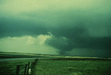
Looking in the same direction (northwest), but from beneath the storm, we observe another mature tornado with a clear slot RFD wedging in between the wall cloud and flanking line. A large area of rain-free base is apparent to the east of the tornado.

Photograph by: Moller
About 10 minutes later, the tornado lifts after its inflow has been cut off by the advancing RFD. A new wall cloud (extreme right) has formed from beneath the rain-free base, 3 or 4 miles east-southeast of the dying tornado. Within about 20 minutes this wall cloud fostered a violent, 1 mile wide tornado. These tornadoes occurred in the Alfalfa and Binger, Oklahoma. A limited amount of data indicates that 20 minutes is about average for periodicity of cyclic storm tornadoes.
|
Evolution (photos) |
|
more tornadoes |