
|


To illustrate these points further, let us imagine that radar and spotters detect a possible supercell that is approaching a community. The spotter group's net controller first considers that the spotters must concentrate on that portion of the supercell which is most important: The quadrant with the updraft/downdraft interface.
If we center a coordinate axis and grid system on the storm's radar centroid, the "action" area typically is in the southwest quadrant as seen in this storm's horizontal cross-sectional view. Warm, ground-relative inflow winds are depicted by orange arrows and cold outflow is in blue, with the longest arrows suggestive of the strongest winds. The gust front is depicted by the thick, blue line, and the mesocyclone by the "L", or low pressure center in the gust front wave.
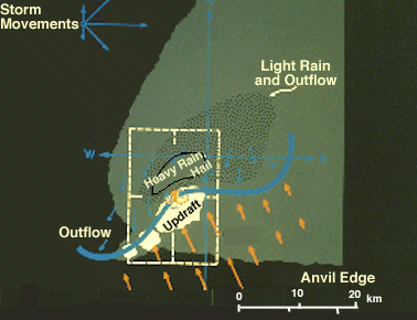
Note the storm motion vectors. Although a majority of these supercells move northeast or east, a significant number move southeast. Therefore, the heaviest precipitation usually either precedes the tornado (northeast movement) or falls immediately north of the tornado track (southeast movement), although brief bursts of large hail and/or rain often occur with the tornado.
Supercells frequently move to the "right" of non-supercell storms, even to the extreme of moving southeast on a day when winds aloft all blow from the southwest. Vigorous development on the south side of the main updraft apparently causes this rightward storm motion. Let us now concentrate on the storm flank where the most violent weather will occur.
|
tornadic supercell |
|
storm evolution |