
|


To do this, we "zoom in" and move the grid system to center it on the wall cloud and updraft area. The darkly-stippled precipitation area narrows to the radar pendant echo, that wraps around the white updraft area and the white-stippled wall cloud.
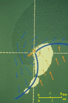 |
Spotter
reports of strong, warm inflow winds southeast
of the wall cloud suggest a higher tornado risk
than the case where the wall cloud is undercut
by outflow. Indeed, note the symbol "T", for
tornado, and the incipient tornado track (solid
orange line), indicating that a tornado has
developed.
Knowledgeable spotters likely will have reported wall cloud persistence and rapid motions prior to tornado formation. We suggest that spotters have a county-wide grid system and compasses so that wall cloud positions can be readily triangulated, and that subsequent inflow and outflow circulation information can be solicited by the net controllers from spotters who are in the appropriate geographical locations. |
During the mature stage of the tornado, the rear flank downdraft (RFD) air accelerates, causing the gust front and flanking line to surge rapidly eastward relative to the tornado. Damaging winds are possible along this flanking line gust front, and small gustnadoes often occur.
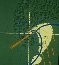 |
Note that radar-indicated precipitation is wrapping cyclonically around the tornado; and that the advancing gust front is cutting off warm air inflow to the tornado. Spotters south of the tornado probably would witness a sharp gust front passage. |
The question mark on the accelerating gust front draws our attention to whether or not a second wall cloud is beginning to form several miles east or southeast of the existing tornado. It is extremely easy to miss such a feature with all eyes on the pre-existing tornado! The gust front has completely isolated the tornado from warm inflow and vortex dissipation is imminent.
 |
As the RFD
progressively wraps around the tornado,
it frequently results in a visible "clear slot"
of relatively cloud-free air wrapping cyclonically
around the tornado's south and east sides.
Cold air downbursts impinging upon the tornado cause the visible funnel cloud to tilt increasingly from the vertical (usually away from the rain area). This vortex stretching is partially responsible for the tornado entering into the "shrinking" or "rope" stage. It is the most likely time for the tornado to make left or right turns from its path, depending on the angle of attack of cold downbursts on the vortex. |
In this example, a new wall cloud has developed several miles to the inflow side (east or southeast) of the dissipating tornado. Storm spotters must be acutely aware of this possible development, which indicates a possible cyclic supercell storm, capable of producing more than one tornado. A repeat of the gust front evolution we have shown is likely if additional tornadoes develop.
|
mesocyclone |
|
Tornadoes |