
|


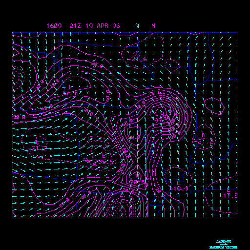
Example Moisture Convergence and Wind Vectors
This panel depicts surface wind vectors and moisture convergence. This chart is most useful in locating areas where thunderstorms will develop.
The solid red contours represent moisture convergence. Moisture convergence has a contour interval of 10 g/kg per second. The chart above is usually factored by 1000 to make the values easier to contour. Moisture convergence is a very important tool in forecasting the development of thunderstorms in the short term. Two of the primary factors in developing thunderstorms are a supply of moisture and low-level convergence. These two quantities are combined in this chart to give you moisture convergence. Surface moisture convergence generally precedes the development of thunderstorms by a few hours.
The blue arrows represent wind vectors. Wind vectors point in the direction the wind is blowing, and the longer the wind vector, the stronger the wind. From the map above you can easily find warm, cold, occluded, and stationary fronts. Fronts are usually located in areas were winds come together and change direction. Low and high pressure systems can also be located from the map above. Winds around low pressure move counter-clockwise (cyclonic) and in towards the center. While winds around high pressure move clockwise (anticylonic) and out away from the center.
The above example image is from April 19, 1996 taken at 4pm in the afternoon. From approximately 6-10pm 30 tornadoes ravaged the state of Illinois. Moisture convergence was a very important tool that day in forecasting the initiation of severe thunderstorms.
|
mixing ratio |
|
temp. advection |