
|


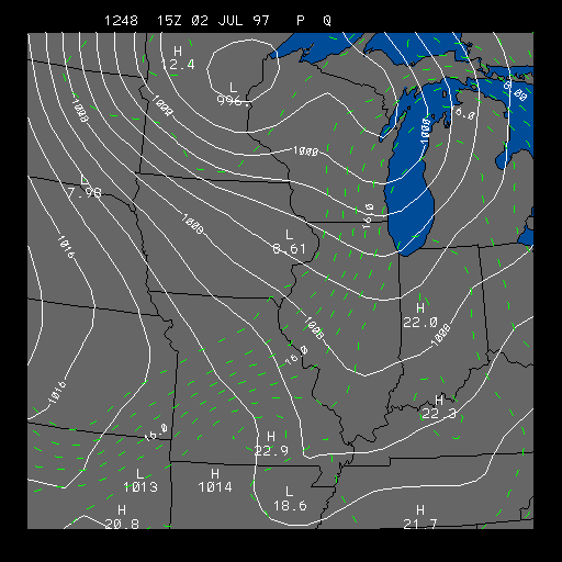
Example Pressure and Mixing Ratio
This panel depicts sea-level pressure and mixing ratio. This chart is useful for finding high and low pressure systems. Its also useful for showing regions of moist air at the surface.
The solid white contours represent pressure contours (isobars) in millibars. The isobars have a contour interval of four millibars. The wind speed is directly related to the distance between the isobars. The closer the isobars are together, the stronger the pressure gradient, and the stronger the wind.
The dashed green lines represent lines of equal mixing ratio. Mixing ratio has a contour interval of two grams per kilogram. Mixing ratio is another convenient way to express humidity. Mixing ratio is the mass of the water vapor in a parcel to the mass of the remaining dry air. Another way to express that is Mixing ratio = mass of water vapor / mass of dry air. The units are grams per kilogram. Example: If you have a mixing ratio of 5, that means you have 5 grams of water vapor to every kilogram of dry air.
From the map above you can sometimes find warm fronts, cold fronts, and drylines. Fronts are usually located where the mixing ratio changes drastically over a short distance. A dryline is also an area where mixing ratio changes drastically over a short distance. During the day, temperatures are warmer west of the dryline and at night they are warmer on the east. Drylines can usually be found in the Plains during the development of low pressure systems.
This image shows a very strong dryline (coldfront) located over the Midwest. The strong front preceded the tornado outbreak on July 2, 1997 that hit parts of Michigan, Indiana and Ohio.
For more information on how pressure affects the weather go to our pressure module.
|
wind |
|
moist. convergence |