
|


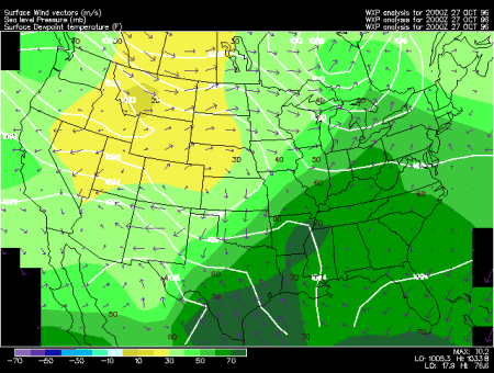
This surface meteorological chart illustrates the distribution of moisture, the sea level pressure and surface flow patterns over the continental United States, and is updated every hour.
Dew point temperature is a measure of moisture in the air. It is reported in degrees Fahrenheit, and contoured every 10 degrees. The overlaid light contours, called isobars, depict sea level pressure. The wind vectors represent the horizontal wind at the surface. The arrows point in the direction in which the wind blows. The winds are in meters per second, with the scale vector of 10 m/s.
When the dew point temperature is close to the temperature of the air, the air is nearly saturated. However, nearly saturated air is not always humid. Only when the temperatures reach above 70 degrees Fahrenheit and dew points rise nearly as high does the air feel "muggy" and uncomfortable. Humidity of the air generally increases southward, similarly to the temperatures. During the summer dark green shading (dew points in the 60s or higher) indicates humid air. Dew points in the 40s or lower (light green, yellow or white) are considered dry. In the winter the dew points are on average 30-40 degrees lower, similarly to the temperatures (except the southern coastal regions where the fluctuations are a little smaller).
Humidity decreases the convective stability of the air. Since the density of moist air is lower it tends to rise over colder, denser air. This can happen along a frontal boundary or if air becomes convectively unstable and rises to form clouds and precipitation. This is why thunderstorms and convective showers often form in a warm, moist airmass. Sharp gradients (closely packed dew point contours) are often indicative of surface fronts or dry lines. During the warm season intense precipitation often occurs along those boundaries.
Surface fronts or dry lines, are also often characterized by a rapid shift in wind direction and sometimes speed. Note that surface winds tend to flow out of the areas of High pressure as they rotate clockwise around its center, and into the areas of Low pressure, as they rotate counter-clockwise around its center. This is associated with the role surface friction plays in the force balance. Areas on the map where the wind blows approximately at a perpendicular angle to the dew point temperature contours from high to low values are regions of strongest moisture advection. Wind vectors pointing from lower toward higher dew points represent advection of drier air (negative moisture advection). Strongest moisture advection typically occurs during the warm seasons in a southerly flow from over the Gulf of Mexico, ahead of cold fronts or dry lines. Advection of warm air and moist air generally overlap and lead to destabilization of air and subsequent formation of clouds and precipitation.
|
dew point reports |
|
24 Hour Totals |