
|


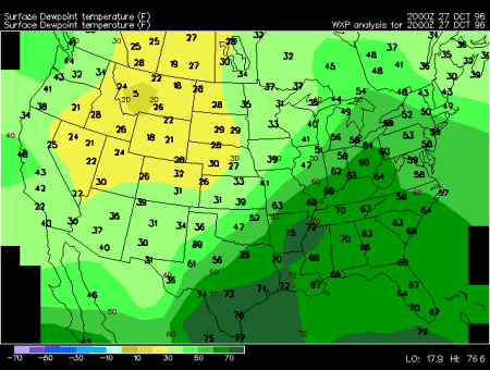
This surface meteorological chart illustrates the distribution of moisture over the continental United States and is updated every hour. Dew point temperature is a measure of moisture in the air. It is reported in degrees Fahrenheit, plotted on this this map at the locations of individual stations, and contoured every 10 degrees.
When the dew point temperature is close to the temperature of the air, the air is nearly saturated. However, nearly saturated air is not always humid. Only when the temperatures reach above 70 degrees Fahrenheit and dew points rise nearly as high does the air feel "muggy" and uncomfortable. Humidity of the air generally increases southward, similarly to the temperatures. During the summer dark green shading (dew points in the 60s or higher) indicate humid air. Dew points in the 40s or lower (light green, yellow or white) are considered dry. In the winter the dew points are on average 30-40 degrees lower, similarly to the temperatures (except the southern coastal regions where the fluctuations are a little smaller).
Humidity decreases the convective stability of the air. Since the density of moist air is lower it tends to rise over colder, denser air. This can happen along a frontal boundary or if air becomes convectively unstable and rises to form clouds and precipitation. This is why thunderstorms and convective showers often form in a warm, moist airmass. Sharp gradients (closely packed dew point contours) are often indicative of frontal boundaries or dry lines. During the warm season intense precipitation often occurs along those boundaries.
|
temperatures, winds |
|
dew points, winds |