
|


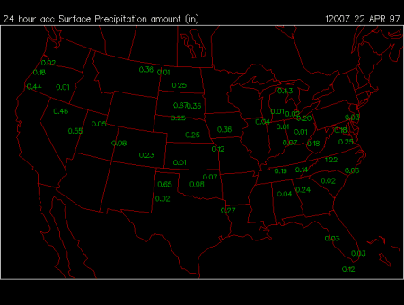
Total Surface Precipitation in 24 hours prior to 1200Z
This surface meteorological chart illustrates the distribution of accumulated precipitation over the continental United States and is updated daily. The 24-hour totals are reported in inches and represent the liquid equivalent of the cumulative precipitation. In case of snow or hail, freezing rain or sleet, the total amounts represent the depth of the melted cumulative precipitation at any surface location.
During the warm season large amounts of cumulative 24hr precipitation in any region can represent heavy downpours from thunderstorms and convective showers, or persistent long-lasting precipitation associated with overrunning near warm frontal boundaries. During the winter, large amounts of cumulative precipitation can be attributed to upslope snow events in the mountains, to lake effect snowstorms in the Great Lakes region, to warm frontal snowfall, or to Northeasters on the East Coast. In the Southeast heaviest rainfall in the late summer and fall often results from hurricanes and tropical storms which make landfall in the coastal regions.
In flat regions, such as the Mississippi Valley in the Midwest, large amounts of cumulative rainfall can lead to flooding. Flash Floods can occur in the mountain valleys, where strong thunderstorms can produce large amounts of rain in short periods of times. In the West, where the mountains provide a natural barrier for the air flowing from over the pacific ocean, persistent warm and moist flow, can lead to flooding conditions in river valleys and mud slides on the western mountain slopes.
The cumulative precipitation map provides a history of passages of storm systems which produce large amounts of precipitation. It represents the past, rather than the current conditions, as often it may be clear and sunny in areas where a lot of precipitation has fallen in the past 24 hours.
|
minimum temps |
|
snow cover |