
|


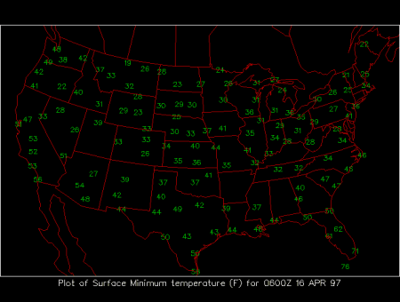
24-hour Minimum Surface Temperatures
This meteorological surface chart shows the minimum temperatures during a 24 hour period prior to 0600Z of the date shown in the upper right hand corner. The minimum temperatures are displayed in degrees Fahrenheit at chosen surface stations.
This map should roughly resemble the current temperature map, but significant differences will arise from quick moving storm systems, as well as from variable amount of local radiational cooling brought on by weak winds during the night. Dry, clear conditions, characteristic of a continental airmass, allow large amounts of infrared energy to be radiated by the earth's surface out to space, decreasing the surface air temperature. Cloudy conditions as well as very moist air, prevent the infrared radiation from being emitted to space. Radiative cooling is most effective during the winter, when there is snow cover on the ground, and in absence of warm air advection. Warm advection can offset the effects of radiational cooling, especially in case of strong warm fronts. Large diurnal variations (daily differences between daytime high and nighttime low temperatures) occur on clear, dry days. Generally minimum temperature for the day occurs in the early morning hours, just before sunrise. However, low temperatures can occur at unusual times of the day or night, due to cold and warm surface fronts passing through the region.
|
maximum temps |
|
24 hour precip |