
|


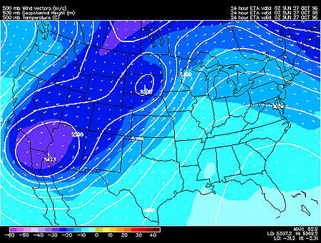
This panel shows 500 mb forecasted fields for geopotential height, temperature and wind vectors. 500 mb charts depict conditions in the middle troposphere (roughly 5000 meters).
Geopotential height approximates the actual height of a pressure surface above mean sea-level and is represented by the solid white contours. The geopotential height field is given in meters with an interval of 60 meters between height lines. The 500 mb height field encircling the globe consists of a series of troughs and ridges, which are the upper air counterparts of surface cyclones and anticyclones. The distance from trough to trough (or ridge to ridge) is known as the wavelength. Typically waves at 500mb are known as long waves. Embedded within the long waves are short waves, which are smaller disturbances often responsible for triggering surface cyclone development.
Wind vectors provide information about wind direction and wind speed and are drawn here as tiny red arrows. Wind vectors point towards the direction in which the wind is blowing and the longer the wind vector, the stronger the wind. The unit of magnitude for wind speed as depicted by the wind vectors is meters per second.
Temperature is represented by the color filled regions and the associated values are indicated by the color code located in the lower left corner of the forecast panel. Temperatures are given in degrees Celsius with an interval of 5 degrees Celsius between temperature contours, also called isotherms.
In this particular image, the important features are the two closed lows in the western half of the continental United States. Notice that the temperature is relatively cold in the center of the troughs. These cold temperatures can act to intensify upward motion caused by the troughs.
When cold advection occurs into a trough (and warm advection into a ridge), this acts to amplify the wave in the geopotential height field. When the wave is amplified, vertical motions intensify, providing energy for a developing cyclone.
|
500 hghts, vorticity |
|
700 hghts, humidity |