
|


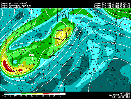
This panel shows 500 mb forecasted fields for geopotential height, absolute vorticity and wind vectors. 500 mb charts depict conditions in the middle troposphere (roughly 5000 meters).
Geopotential height approximates the actual height of a pressure surface above mean sea-level and is represented by the solid white contours. The geopotential height field is given in meters with an interval of 60 meters between height lines. The 500 mb height field encircling the globe consists of a series of troughs and ridges, which are the upper air counterparts of surface cyclones and anticyclones. The distance from trough to trough (or ridge to ridge) is known as the wavelength. Typically waves at 500mb are known as long waves. Embedded within the long waves are short waves, which are smaller disturbances often responsible for triggering surface cyclone development.
Wind vectors provide information about wind direction and wind speed and are drawn here as tiny red arrows. Wind vectors point towards the direction in which the wind is blowing and the longer the wind vector, the stronger the wind. The unit of magnitude for wind speed as depicted by the wind vectors is meters per second.
Absolute vorticity is represented by the color filled regions and the associated values are determined by the color code in the lower left corner of the forecast panel. Absolute vorticity values are given in units of 10e-5 seconds^-1 with an interval of 4X10e-5 seconds between vorticity contours.
In this particular image, the most noteworthy feature is the maximum in vorticity located just off the southern coast of California. Vorticity advection due to this maximum will likely spawn a surface cyclone just to the east of the vorticity maximum.
Vorticity is measurement of the spin of air parcels. In meteorology, we are most concerned with the spin of horizontally flowing air about a vertical axis. Of most interest are localized regions of much higher vorticity values, called positive vorticity maxima (generally above 16 X10e-5 s^-1). East of a vorticity max., upward motion helps to strengthen surface low pressure centers and induce precipitation. Conversely, west of a vorticity maximum, air is generally sinking, resulting in fair weather.
|
300 hghts, temps |
|
500 hghts, temps |