
|


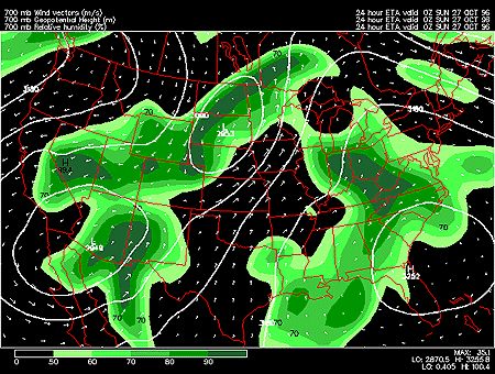
This panel shows the 700 mb forecasted fields for geopotential height, relative humidity and wind vectors. 700 mb charts depict conditions in the middle troposphere (roughly 3000 meters). This is also referred to as the steering level, since most weather systems are "steered" by the winds at this level.
Geopotential height approximates the actual height of a pressure surface above mean sea-level and is represented by the solid white contours. The geopotential height field is given in meters with an interval of 30 meters between height lines. The locations of surface cyclones and anticyclones hold similar positions in the 700 mb geopotential height field.
Wind vectors provide information about wind direction and wind speed and are drawn here as tiny white arrows. Wind vectors point towards the direction in which the wind is blowing and the longer the wind vector, the stronger the wind. The unit of magnitude for wind speed as depicted by the wind vectors is meters per second.
Relative humidity is represented by the color filled regions and the associated values are indicated by the color code located in the lower left corner of the forecast panel. Relative humidities are given in percent with an interval of 10% between the shaded humidity contours. Humidities of 50% and greater are shaded in varying colors of green, while humidities less than 50% are not shaded.
In this particular image, the important feature is the high relative humidity air over most of High Plains and Rocky Mountain region as well as the Ohio Valley and Mid-Atlantic coast. When relative humidity is high, expect clouds to be present in these regions.
The higher the relative humidity, the more moist the air, which is vital for the development of clouds and precipitation. 700 mb relative humidities of 70% and greater indicate the likely presence of cloud cover in these regions. Also, the absence of high relative humidity air can help intensify thunderstorms through strong downdrafts caused by cooling due to evaporation.
|
500 hghts, temps |
|
700 vvel, precip |