
|


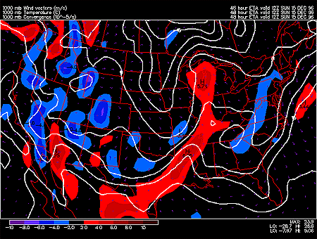
This panel shows 1000 mb forecasted fields for convergence, temperature and wind vectors. The solid white contours represent temperature in degrees Celsius with an interval of 5 degrees. The temperature field is useful for locating warm and cold air masses and associated surface fronts.
Wind vectors provide information about wind direction and wind speed and are drawn here as tiny white arrows. Wind vectors point towards the direction in which the wind is blowing and the longer the wind vector, the stronger the wind. The unit of magnitude for wind speed as depicted by the wind vectors is meters per second.
Convergence is represented by the color filled regions and the associated values are indicated by the color code located in the lower left corner of the forecast panel. Regions of convergence are shown in red and regions of divergence are shown in blue.
In this particular image, the important feature is the line of convergence extending from Wisconsin through Illinois to Arkansas and Texas. This line on convergence is associated with a cold front. Clouds and precipitation would be expected to occur along this cold front.
Convergence means that more air is flowing into that region than flowing out. Since the air has to go somewhere, it rises and rising air is what induces precipitation development. Heavier precipitation is often associated with regions of stronger (>2) convergence. The opposite is true for areas of divergence, where more air is flowing out of the region than flowing in. To replace the net loss of air, air sinks from above and sinking air suppresses the development of clouds and precipitation.
|
850 hghts, temps |
|
sfc precip, prs, thk |