
|


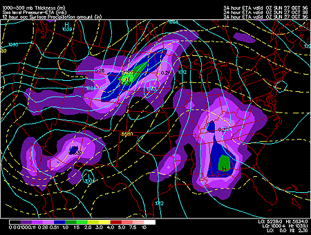
This panel shows the forecasted fields for mean sea-level pressure, 1000-500 mb thickness and surface quantitative precipitation.
Mean sea level pressure is simply the pressure at mean sea level and is represented by the solid blue contours. The mean sea level pressure field is given in millibars with an interval of 4 mb between pressure contours, also called isobars. The locations of high and low pressure systems can be determined from the sea level pressure field. Winds tend to blow clockwise around areas of high pressure and counterclockwise around areas of low pressure. The closer together the isobars, the stronger the winds.
1000-500 mb thickness indicates the distance in meters between the 1000 mb and 500 mb pressure surfaces and is represented by the dashed yellow contours. The thickness field is given in meters with an interval of 60 meters between thickness contours. Thickness is directly related to temperature; as thickness decreases, so does temperature. Precipitation type can also be estimated from the thickness field with the 5400 meter thickness serving as the rain/snow line. Snow falls where thicknesses are below 5400 and rain occurs where they are greater.
Quantitative precipitation is represented by the color filled regions and the associated values are indicated by the color code located in the lower left corner of the forecast panel. Precipitation totals are given in inches with totals of less than 0.51 inches shaded in purple with heavier totals shaded in green, yellow and red. Quantitative precipitation is the estimation of the liquid equivalent precipitation that would occur during the 12 hour period. For example, quantitative precipitation fields for 0000Z 24 March 1996 represent the amount of precipitation that is predicted to occur from 1200Z 23 March to 0000Z 24 March 1996.
In this particular image, the important feature is the surface cyclone located in the southeast corner of South Dakota. As much as 1.5 to 2 inches of liquid equivalent precipitation is expected over the 12 hour period ending at 0000Z October 27 1996. Most of this precipitation should fall as rain (or freezing rain) since the 1000-500mb thickness is above 5400m in that region.
|
1000 convrg & temp |
|
Projects, Activities |