
|


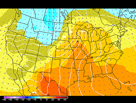
This panel shows the 850 mb forecasted fields for geopotential height, temperature and wind vectors. 850 mb charts depict conditions in the lower troposphere (roughly 1500 meters).
Geopotential height approximates the actual height of a pressure surface above mean sea-level and is represented by the solid white contours. The geopotential height field is given in meters with an interval of 30 meters between height lines. The locations of surface cyclones and anticyclones hold similar positions in the 850 mb geopotential height field.
Wind vectors provide information about wind direction and wind speed and are drawn here as tiny purple arrows. Wind vectors point towards the direction in which the wind is blowing and the longer the wind vector, the stronger the wind. The unit of magnitude for wind speed as depicted by the wind vectors is meters per second.
Temperature is represented by the color filled regions and the associated values are indicated by the color code located in the lower left corner of the forecast panel. Temperatures are given in degrees Celsius with an interval of 5 degrees Celsius between temperature contours, also called isotherms.
In this particular image, the important features are
the deep low over the Northern Great Plains. Warm air
is being transported on the east side of the low, while cold air is being
transported on the west side of the low. Snow is likely to fall in
the western Dakotas and eastern Montana since the temperature is below
freezing in these locations.
Temperature at 850 mb does not
experience the diurnal variation as seen at the surface, so this is a good
indicator where warm air and cold air is located.
Precipitation type can also be estimated from the 850 mb temperature field.
Snow is likely to occur where the 850 temps are below freezing (zero and below),
while liquid precipitation is found at warmer temperatures.
Also, vertical motion occurs in the presence of
temperature advection.
Warm advection causes upward motion, while
cold advection causes downward motion.
Finally, if cold advection occurs underneath an upper level
trough, then the trough will amplify and strengthen a
surface cyclone.
![]()
850 hghts, humidity
Terms for using
data resources.
CD-ROM available.
Credits and Acknowledgments for
WW2010.
Department of Atmospheric
Sciences (DAS)
at
the University of Illinois at Urbana-Champaign.
![]()
1000 convrg & temp