
|


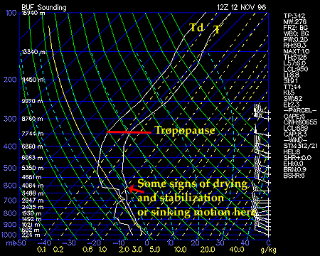
At this point in the storm, the profile of temperature and dew point start to change, signaling the winding down of the lake-effect storm. A weak capping inversion in the lower layers appears to be taking shape at about 750 mb - a sign that stability is increasing in the atmosphere above Buffalo which may hinder the vertical extent of the clouds. The intensity of the snow squalls developing in the eastern lakes was observed to be on the decrease. In addition, the dew point sounding is farther removed from the temperature line indicating some drying of the atmospheric column. This could make it increasingly difficult for air parcels, originating near the lake, to reach saturation and form clouds and precipitation. Finally, the sounding is more stable throughout; even in the lower layers the lapse rates appear to be greater than pseudoadiabatic values.
After this sounding was taken, warming continued at mid-levels and the LES event slowly - very slowly - came to an end. The most unstable air is translating eastward during this period. Thus, the eastern snowbelts of Lake Ontario are in the most favorable region for heavy snow. Some towns downwind of Lake Ontario between Oswego and Syracuse will approach or exceed 40" of snow when the final snow amounts are tallied.
|
Nov 11, 1996 12z |
|
Upper Air Data |