
|


The three soundings presented here are taken at the same time - Nov 11, 1996 at 12Z. The three locations are Green Bay, WI, Detroit, MI, and Buffalo, NY. The air flow in this storm (both at the surface and aloft) blows roughly parallel to the line connecting these three cities; thus, looking at these soundings in a series, one gets a sense of how the air column is modified as it crosses Lakes Michigan and Erie.
The first sounding below, from Green Bay, should be the coldest, driest, and most stable along the trajectory. This is because the air flow has not traversed any of the Great Lakes (at least to any large degree). The air mass over Green Bay at this hour is cold, dry, and relatively stable air on its way from central Canada. However, this sounding is not "bone dry" and there appears to be a possible cloud deck about 800 mb or approximately 6,500 feet as the dew point and temperature lines are close together. Directly above this level there is a shallow inversion layer where temperature increases with height. This inversion is called a capping inversion because it will tend to inhibit any air parcels from rising much above the inversion height. There is another inversion right at the surface, but this is more a result of time of day than any dynamic influence - radiative cooling of the surface at night will form this inversion and daytime heating and mixing of the lower layers will eliminate it quickly in the morning hours.
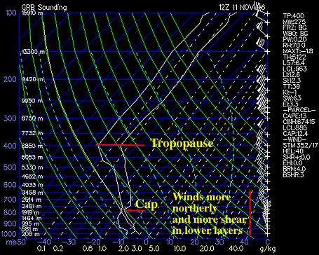
Above the capping inversion at 800 mb the column cools slightly up to 400 mb where we have noted the top of the troposphere. This is a low troposphere height (typically 200-250 mb is more common) and indicates the proximity of the deep upper level low pressure nearby. As a rule the tropopause will lower significantly in cold core systems such as these. Winds at Green Bay are mostly northwesterly or NNW through the sounding indicating Green Bay's orientation to the upwind side of the large scale trough. These wind profiles will change significantly by the time the airflow reaches Buffalo, NY.
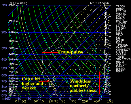
At 12Z on November 11, 1996 the Detroit, MI sounding is presented (below). The capping inversion is now found at about 700 mb which is a significant change from the Green Bay sounding. The atmosphere is a bit more moist in the mixed layer below the cap and is quite a bit warmer in general. There is a shallow inversion at the surface as might be expected since Detroit had only partly to variable clouds - so some radiational cooling had taken place. These are all expected conditions considering the flow has traversed Lake Michigan, picking up a good deal of heat and moisture. Above the mixed layer, the sounding is similar to Green Bay - although it appears to be drier. Winds are northwesterly to WNW and are very steady in direction and speed throughout a great depth of the column. This is good evidence that little shear would be expected in the over-lake regions.
We finally reach our last destination - Buffalo, NY. This sounding is quite a bit different. Winds are mostly westerly to WNW and well aligned with little speed shear in the vertical through the depth of the troposphere. There is no capping inversion, within the troposphere, to speak of. Air crossing Lake Erie and other upstream lake waters has completely eroded the cap - most likely through "penetrative convection" of warm air thermals from the lake surface. This is a remarkable sounding for an LES event. It implies that the heat and moisture from the lake surface can easily mix to very high levels in the atmosphere producing deep wintertime convection. The lapse rate is nearly psudoadiabatic up to about 550 mb where the profile becomes a bit more stable.
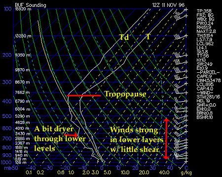
This is an environment where it is quite easy to build deep cloud bands and snow squalls with only a bit of help from such mechanisms as land breezes, thermal troughs, and frictional convergence. This is why "thunder-snow" was so prevalent around the region during this event. Finally, the surface temperatures are near freezing and there is only a slight hint of a surface inversion suggesting that little radiational cooling took place overnight. Indeed, cities close to the lee shores of the lakes are strongly influenced by the lake temperature compared to other factors - especially in LES scenarios.
|
Nov 10-11, 1996 |
|
Nov 12, 1996 |