
|


On the morning of November 10, 1996, cold air was beginning to arrive in the eastern Great Lakes. The sounding below from Buffalo, New York was taken as a surface and upper level low pressure were nearby.
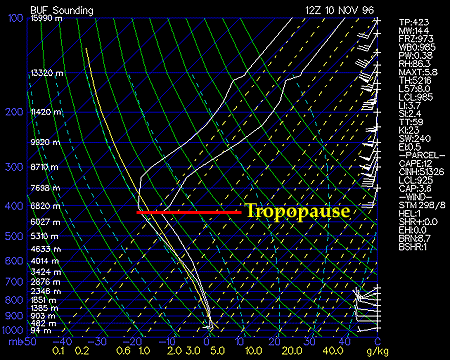
The tropopause, (the boundary between troposphere and stratosphere), is found at 423 Mb which is pretty low for this time of year and the synoptic conditions. Winds are increasing with height and mostly southwesterly indicating Buffalo's position on the downstream arm of a large upper level trough. The temperature curve is very smooth and lacking any inversions or other "kinks" indicating a deep layer of "conditionally" unstable air. The dotted blue lines on the Skew-T diagram indicate pseudo-adiabats which are thermodynamic curves of temperature reduction with height in moist or saturated layers. Note, the temperature curve closely follows the slope of the pseudo-adiabats.

Later on Sunday (00Z Nov 11, 1996) lake-effect snows are beginning to increase off the eastern end of Lake Erie. At this time, the sounding is still conditionally unstable through a large depth of the column and is a bit colder, in general, compared to the previous sounding. The dew point curve is even closer to the temperature curve indicating a good deal of moisture available for cloud and precipitation production. A slight inversion is found at 550 mb which will hardly inhibit vertical cloud development in this area. Much of the wind data is missing, but the available observations suggest that winds in the mid and upper levels are "veering" to a more southwesterly and westerly direction with time - indicating the eastward progression of the upper level low and trough axis.
|
introduction |
|
Nov 11, 1996 12z |