
|

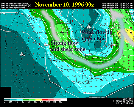
In our case, this is a classic setup for a big LES event. The closed low and unusually cold air aloft allows plenty of time for cold surface winds to blow across the open waters of each lake and produce convective snowbands and snow squalls. The flow about midway through the troposphere (at 500 millibars, or about 5400 meters ~ 18,000 feet) features a deep upper level low pressure centered near Lake Superior on Nov 10, 1996 at 00Z (see below). This upper low is a pool of cold air aloft, and the center of a broad counterclockwise or cyclonic circulation which includes most of the eastern half of the US. In our case, the strongest flow is far away from the upper low center and is denoted as the area of "strong flow and shear zone" on the map below.
|