
|


The following images, reproduced with permission from WSI Corporation, show the Doppler radar precipitation estimates integrated for two periods during the storm (these are liquid water equivalents). In both cases, the precipitation amounts appear more widespread than the observed snowfall distribution. The local maxima of water equivalent as totaled from the radar algorithms shows a clear maxima near the Lake Erie shoreline in NE Ohio (Lake County). When precipitation is in the form of snow, the snowflakes might be blown or "advected" 50 km or more under strong wind conditions. In our case, the winds were weak to moderate and the snowflakes were quite wet and heavy so it is seems quite reasonable that the flakes might translate 10-15 km downstream. In any event, this is one issue that adds uncertainty and might explain the discrepancy between the observations and the distribution shown below.
The distribution of precipitation in western lower Michigan is classic for this type of event. Snowfall is widespread near the east shore of Lake Michigan, but there are two maximas found in the south and the north end of the shoreline. The prevailing wind in this storm blows approximately "normal" or perpendicular to the long axis of Lake Michigan which tends to produce multiple-band or widespread lake effects. There is ample evidence of this in the precipitation integration.
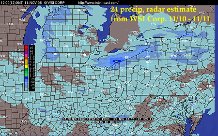
Reproduced with Permission © WSI Corporation 1996,1997 (intellicast)
In the following image, less water equivalent precipitation is derived across the area as the storm is winding down - also, the interval of measurement is only 12 hours versus 24 hours for the previous image. The liquid equivalent indicated in north-central Ohio does not verify against ground observations. Much of this precipitation was virga or precipitation aloft in association with the return of warmer air into the region - which signaled an end of the LES storm.
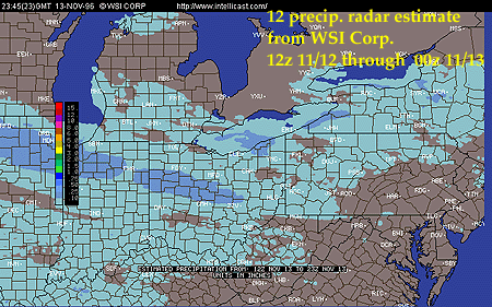
Reproduced with Permission © WSI Corporation 1996,1997 (intellicast)
|
snow images |
|
Radar Imagery |