
|


On Monday morning November 11, 1996, strong lake effect snowbands developed on the NE Ohio lakeshore. These bands migrated southward during the evening of the 10th from a position near Erie, PA to the indicated position found on this WSR 88-D NEXRAD radar image from the National Weather Service Forecast Office (NWSFO) and Doppler radar site in Cleveland, Ohio. Notice that the snowfall is quite variable in Greater Cleveland with widespread areas of no reflectivity and isolated instances of radar reflectivity factor approaching 35 dBZ, about as intense as snowfall is observed on radar.
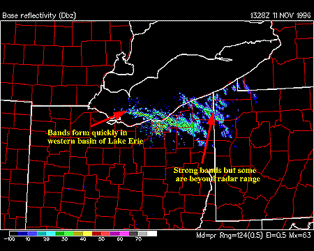
At this juncture, the bands are nearly stationary oriented WNW - ESE across Lake Erie. Impulses of strong convection within the bands are propagating along the band axes. There are multiple strong lake snowbands over the southern half of Lake Erie. The band in extreme northeast Ohio, in Ashtabula County, is likely as strong as the main band near downtown Cleveland and the eastern suburbs; this is known because of snow spotter reports during this time.
The band in extreme NE Ohio does not show up as well due to overshooting and attenuation of the radar beam (i.e. it is near the useful range of the KCLE (Cleveland) Doppler radar as determined by the band's cloud tops). Incidentally, effective radar ranging or coverage during LES events is an important issue amongst NWS forecasters in the Great Lakes region and is being addressed in a recent study by the NWS region called the NWS LES study. Preliminary results from this study indicate that extreme NE Ohio and NW Pennsylvania are not well covered by KCLE radar in 15-20% of lake effect snowfalls in the region.
An interesting pattern develops during the daytime hours as seen in this image taken around 19Z from KCLE NEXRAD Doppler Radar. Widespread cellular or "popcorn" convection is evident throughout the radar scanning range - particularly over the land. Remember, this is an early season snowstorm so much of the surrounding land outside of the snowbelts is snowfree. Moreover, the daytime sun is still warm enough to heat up the land which helps increase the instabilty near the ground; this results in small cellular convective clouds and precipitation. The cellular convection was seen throughout the GL's and midwest - particularly on November 11th and 12th, 1996.
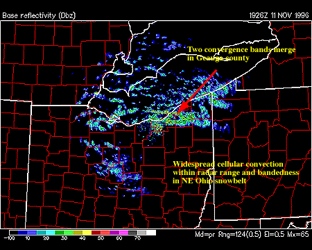
It appears from surface reports and the radar imagery that the LES bands were weaker during the day than in the evening and overnight hours. At least one NWS forecaster hypothesized that the land-based cellular convection might have played a role in disrupting the LES bands forming over the lake. Indeed, it is clear from this image that individual cells are either forming or migrating over the lake surface and are impinging on the edges of the lake bands. Not much else can be hypothesized from such an image. Explaining scientifically, the interaction of the cellular and banded lake effect convection in this event is an unsolved problem at this point!
|
Nov 10, 1996 |
|
Nov 12, 1996 |