|
|
. |
November 10th 1996, 04Z
surface data analysis
A surface low in northwest Pennslvania (PA)
is producing and
area of snow and rain in the
eastern lakes. The cold front associated with
the low is the leading edge
of the unseasonably cold air which set-off the LES event that persisted
through the next three days.
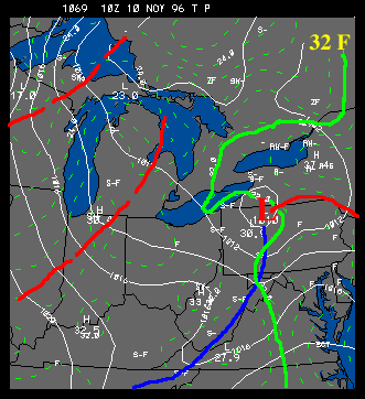 |
At 0400z on November 10 (i.e. late evening on the 9th of Nov), NE Ohio
was receiving locally heavy snowfall as a result of the surface storm.
At this hour snow was falling at the rate of 1-2"/hour in the higher
elevations east and southeast of Cleveland, Ohio. Temperatures were
hovering near freezing, as can be seen in the 32F isotherm highlighted below.
Warmer
air is being wrapped around the backside of the storm through the eastern
lakes. |
|