|
|
. |
Forecasting Near Cold Fronts
colder temperatures and possibly precipitation
A cold front
is defined as the transition zone where a cold air mass
is replacing a warmer air mass.
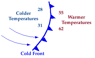
In the example below, temperatures ahead of the cold front are
55 and 62 degrees while behind the front, the
temperatures are lower, 31 and 28.

The air mass behind a cold front
is likely to be cooler and drier than the one before the front.
If a cold front is approaching,
precipitation is possible just before and while the
front passes.
Behind the front, expect clearing skies, cooler temperatures, and lower
relative humdities.
|
