|
Pre-Storm Conditions
how it happened
Early in the morning, a number of meteorologists in the department
of atmospheric sciences were
carefully studying various weather maps and data, trying to determine
if a severe weather outbreak was a possibility. The batteries were charged,
the cars were gased, and the outlook was favorable.
The primary concern
was would the warm front,
which was located in Missouri, push its way
through central Illinois? Morning weather conditions were overcast and
cool, but as the day wore on, temperatures warmed,
dew points slowly
climbed, and at 1:30 PM CDT that afternoon, the decision was made to
drive to western Illinois and see what develops.
And develop it did.
Thunderstorms began to explode throughout Iowa, Missouri and Illinois
after 21Z, or 4:00 PM CDT.
These storms would lead to more than
30 tornadoes in the state of Illinois that afternoon.
This section briefly looks at some key weather maps which provide some
insight in to why the severe weather outbreak occurred.
Pre-Storm
Last Update: 06/27/97 |
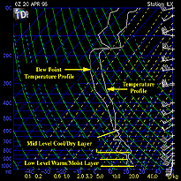
Low Level Warm Moist Air
Warm temperatures and increasing dew points were present at low levels.
Moisture Convergence
Significant moisture convergence was present in eastern Iowa and western
Illinois.
Wind Shear
Directional and speed shear was present between the surface and 700 mb. |

The Damage
|
|

warm moist air
|
|
![[Image: (22K)]](/arch/cases/960419/cnd/gifs/home2.gif)