
|


We will now investigate how Doppler velocity patterns vary in a small area of the display where the flow field is uniform, rotating, and flowing outward from a point. These patterns would be similar to what an operator would see with uniform winds, when a mesocyclone associated with a severe thunderstorm was present, or when a downburst was present. We will view a small area located north of the radar as seen in the figure below.

Image by: Brown & Wood |
This diagram shows the location and size of the 27 x 27 nautical mile displaying window used for simulated Doppler velocity patterns of convective storm features. The window is 65 nautical miles due north of the radar located at the center of the overall display region. |

Image by: Brown & Wood
First, let's look at what a uniform flow field would look like in the small box. The radial velocity pattern on the right is what the radar would see if the wind speed was uniform at 50 knots and the wind was blowing from the west towards the east. Note the zero line goes down the center of the box because the winds are perpendicular to the beam along that line.
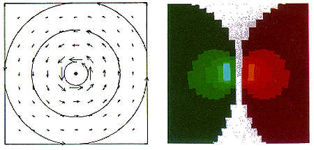
Image by: Brown & Wood
Next we look at a wind field which is rotating about a point at the center of the box. The wind speeds are 40 knots, 2.5 miles from the circulation center, and decrease outward to zero at the edge of the box. This crudely represents the mesocyclone circulation associated with a severe thunderstorm. The Doppler radial velocity display again shows the zero line down the middle of the box since winds along this line are perpendicular to the radar beam. However, to the left and right of the line, a sharp velocity couplet appears with strong outbound velocities just to the right and strong inbound velocities just to the left. This is the classic signature of rotation with strong inbound and outbound velocities flanking the beam axis.
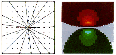
Image by: Brown & Wood
Straight line winds often originate in circulations called downbursts, in which cool descending air strikes the ground at high speed and spreads out in all directions. The leading edge of this cold outflow is called a gust front. The image above shows the Doppler radial velocities associated with an idealized downburst. This Doppler velocity pattern corresponds to an axisymmetric divergent flow where the center of the downburst is in the center of the box 65 nautical miles north of the radar. Note the strong velocity couplet, with the zero line perpendicular to the beam axis and strong inbound and outbound velocities along the beam axis.
|
directional shear |
|
tornado signatures |