
|


This late afternoon New Mexico storm has subtle indications of being multicellular. Can you see the two major updraft areas? You cannot always discern between storm types by visual observations. Radar usually is the best tool for that purpose, but in many cases the visual appearance will yield important clues.
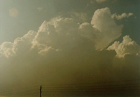
Photograph by: Olthoff
This is the same storm complex less than one our later. The multicell complex apparently has evolved into a storm with one dominant updraft. The storm has become a supercell.

Photograph by: Olthoff
The storms we have seen lead us to ask several fundamental questions: What environmental factors influence the type or types of storms and the intensity of severe weather that occurs on a given day? And why does a storm sometimes evolve from one type to another?
|
LP Supercells |
|
tornadic supercell |