
|


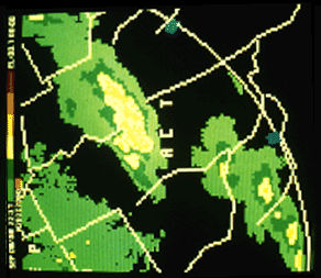 |
Radar (PPI mode) often reflects the multicell nature of these storms, as seen with the central echo mass and its three light red (in this case VIP 5) cores in this photo. Occasionally, a multicell storm will appear unicellular in a low-level radar scan, but will display several distinct tops when a tilt sequence is used to view the storm in its upper extremities. |
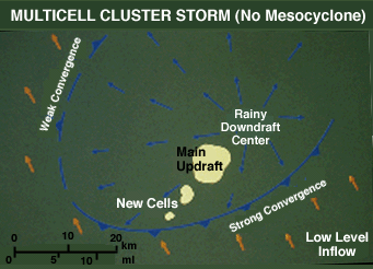
The close proximity of updrafts within the multicell cluster storm results in updraft competition for the warm, moist low-level air. Thus, updrafts never attain extremely strong vertical velocities and each has a short life span when compared to a supercell updraft. Naturally, multicell severe weather usually is less intense than that from supercells, but still can be quite potent, with marble to golf ball size hail and 60 to 80 MPH winds not uncommon.
This low-level, horizontal cross-section depicts a severe multicell storm or marginal supercell where the gust front typically has moved out ahead of and "undercut" the updraft area and possible wall cloud. Although the storm might well be severe, tornado production from the updraft/wall cloud area is unlikely.
|
introduction |
|
development |