
|


A warm front is the transition zone where a warm air mass is replacing a cold air mass. The air behind a warm front is generally warmer and more moist than the air ahead of it. A likely scenario has been depicted below, where temperatures ahead of the front are in the 20's and 30's while behind the front they are in the 50's and 60's.
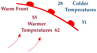
The air mass behind a warm front is likely to be warmer and more moist than the one before the front. If a warm front is approaching, light rain or light winter precipitation is possible before and as the front passes. Behind the front, expect clearing skies, warmer temperatures and higher relative humdities.
The figure below is a vertical cross section depicting the development of precipitation ahead of and along a warm front. The region shaded in blue represents the colder air mass while the yellow areas indicate the warm moist air mass behind the warm front (solid red line).
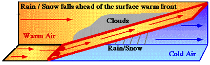
The surface of the warm front extends vertically into the atmosphere, sloping up and over the colder air ahead it. Warm air rides up and over the cold air mass, cooling as it rises, producing clouds and precipitation in advance of the surface warm front. Because the lifting is very gradual and steady, generally wide spread and light-intensity precipitation develops ahead of a warm front.
|
cold fronts |
|
stationary fronts |