
|


A cold front is defined as the transition zone where a cold air mass is replacing a warmer air mass. In the example below, temperatures ahead of the cold front are 55 and 62 degrees while behind the front, the temperatures are lower, 31 and 28.
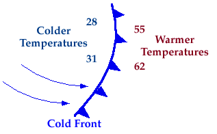
The air mass behind a cold front is likely to be cooler and drier than the one before the front. If a cold front is approaching, precipitation is possible just before and while the front passes. Behind the front, expect clearing skies, cooler temperatures, and lower relative humdities.
The picture below is a vertical cross-section depicting the development of precipitation ahead of and along cold front. The blue mass represents the colder air behind the cold front (solid blue line) and the yellow areas indicate the warm moist air mass ahead of the front.
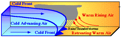
As the cold air mass propagates, it lifts the warmer less dense air ahead of it (red arrows). The air cools as it rises and the moisture condenses to produce clouds and precipitation ahead of and along the cold front. In contrast to lifting along a warm front, upward motions along a cold front are typically more vigorous, producing deeper clouds and more intense bands of showers and thunderstorms. However, these bands are often quite narrow (a couple hundred kilometers across) and move rapidly just ahead of the cold front.
|
cyclones |
|
warm fronts |