
|


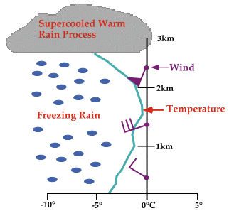
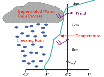
Below is a sounding that typically results in freezing rain through Supercooled Warm Rain Processes (SWRP). Throughout the sounding profile, the temperature never exceeds 0C (32F). The process begins as supercooled raindrops grow by collision and coalescence, and since the temperature throughout the cloud is warmer than about -10C, the cloud is generally free of ice crystals. This is important because if ice crystals were present, the cloud drops would instead grow by ice crystal processes, producing snow and not freezing rain. Winds are typically out of the west or northwest at the surface, veering to the southwest in middle and upper levels.
In the second sounding, the temperature exceeds 0C (32F) above the cloud. This type of sounding is commonly observed in the Southern Plains where very warm mid-level air from the Mexican plateau overrides colder air in the surface layers. Winds at the surface are usually from the east or southeast and veer around to the southwest or west in middle and upper levels.
The best way to forecast freezing rain is to examine forecast model soundings for profiles similar to the ones described in this module. One web site providing these products is the Northern Illinois University's Storm Machine. One can choose the city and model and receive the appropriate forecast soundings, from which a forecast can be made about when and where freezing rain will occur.
|
classic sounding |
|
Precipitation |