
|


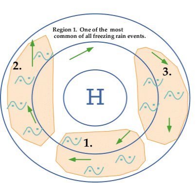
In addition to cyclones and frontal boundaries, conditions associated with surface anticyclones can also lead to the development freezing rain. Three areas of freezing rain (shaded in orange below) are commonly observed in the vicinity of an anticyclone and in all three cases, freezing rain typically develops as southwesterly winds at upper levels transport warm moist air up and over the colder air associated with the high.
Pressure troughs, or dips in the pressure field, may also lead to the development of freezing rain. One type of pressure trough, called a "lee trough", is commonly observed in the central United States. West of the trough, surface winds are usually from the northwest while ahead of the trough, winds are southerly. Westerly winds at upper levels typically transport warmer Pacific air that overruns the colder air at the surface, producing freezing rain.
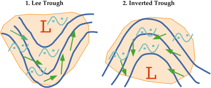
An inverted trough, which is much more common than the lee trough, may also lead to the development of freezing rain. Surface winds west of the inverted trough are north or northwesterly while winds east of the trough are east to northeasterly. The upper-level winds are usually from the southwest to southerly and they overrun the cold air at the surface.
|
cyclones and fronts |
|
special conditions |