
|


A line connecting points of equal pressure
is called an isobar. That means, that at every point along a
given isobar, the values of pressure are the same.
Isobars are represented by solid blue contours.
An image of sea-level pressure reports
and isobars has been given below.
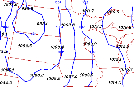
The black numbers are station reports of sea-level pressure in millibars. Isobars are normally drawn at 4 mb intervals, with 1000 mb being the base value. The small blue numbers are contour labels, which identify the value of an isobar (for example 1004 mb, 1012 mb, etc.).
The isobars displayed here have been generated from these pressure observations. For example, pressure reports in South Dakota are 1002.5 mb and 1000.4 mb respectively, and notice that they are contained within the region bound by the 1000 mb and 1004 mb contours.
An area of relatively lower pressure is centered in western North Dakota, while the pressure increases outward from this region.
|
introduction |
|
wind & isobars |