
|


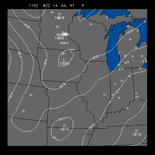
Latest Pressure and Weather Distribution
This panel depicts sea-level pressure and current weather. This chart is useful for finding regions of active weather and high and low pressure systems.
The solid white contours represent pressure contours (isobars) in millibars. The isobars have an interval of 4 millibars. The wind speed is directly related to the distance between the isobars. The closer they are together, the stronger the pressure gradient, and the stronger the wind. Low and high pressure systems can also be located from the map above. Low pressure systems are located in the regions of the lowest pressure, while high pressure systems are located in the regions of highest pressure.
The letters found in the above image indicate what type of weather is currently occurring. The table below can be used to help interpret what each letter in the image stands for. To test your knowledge of weather symbols, try the weather symbol quiz.
Common Weather Symbols
| T | Thunderstorm | T+ | Severe Thunderstorm | R | Rain | RW | Rain Shower |
|---|---|---|---|---|---|---|---|
| L | Drizzle | ZR | Freezing Rain | ZL | Freezing Drizzle | A | Hail |
| IP | Ice Pellets | IPW | Ice Pellet Shower | S | Snow | SW | Snow Shower |
| SP | Snow Pellets | SG | Snow Grains | IC | Ice Crystals | BD | Blowing Dust |
| BN | Blowing Sand | BS | Blowing Snow | D | Dust | F | Fog |
| GF | Ground Fog | H | Haze | IF | Ice Fog | K | Smoke |
| BS | Blowing Spray | + | Heavy | NO SIGN | Moderate | - | light |
For more information on how pressure affects the weather go to our pressure module.
|
dew point |
|
wind |