
|


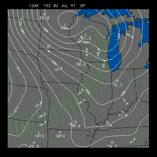
Example Pressure and Dew point Distribution
This panel depicts sea-level pressure and dew point temperature. This chart is useful for finding fronts and high and low pressure systems.
The solid white contours represent pressure contours (isobars) in millibars. The isobars have a contour interval of four millibars. The wind speed is directly related to the distance between the isobars. The closer the isobars are together, the stronger the pressure gradient, and the stronger the wind.
The dashed green lines represent lines of equal dew point (isodrosotherms). The contour interval of the dew point contours is two degrees Fahrenheit. From the map above you can sometimes find warm fronts, cold fronts, and drylines. Fronts are usually located where the dew point changes drastically over a short distance.
A dryline is also an area where dew point changes dramatically over a short distance. This image is a rare example of a very strong dryline (coldfront) across the Midwest. Dew points dropped over twenty degrees behind the front within a matter of a few hours. This preceded the tornado outbreak on July 2, 1997 that hit parts of Michigan, Indiana and Ohio.
For more information on how pressure affects the weather go to our pressure module.
|
press & temp |
|
weather |