
|


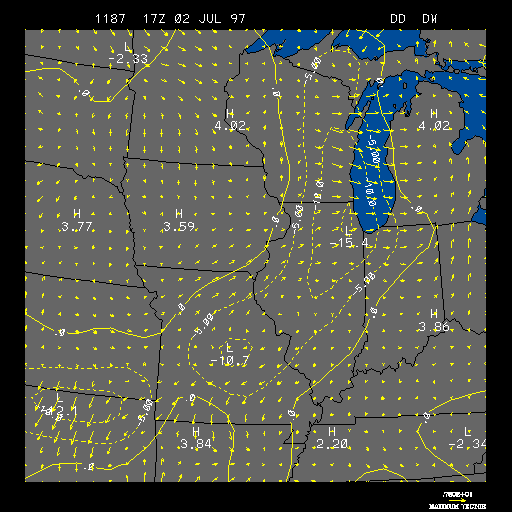
Example Surface 3 Hour Dew point Temperature and Wind Change
This is the Surface 3 Hour Dew Point Temperature and Wind Change image, and on
this image are areas of 3 hour positive and negative
dew point temperature change, plus 3 hour wind
changes. This image is useful in the spring when thunderstorms are a concern.
Positive dew point temperature change areas are contoured in solid yellow lines and indicate that the dew point temperature is rising in that region. Negative temperature change areas are contoured in dashed yellow lines and indicate that the dew point temperature is falling in that region. Both dew point temperature change areas are contoured in intervals of 5 degrees Fahrenheit. Therefore, a positive dew point temperature change contour of 5 would indicate that the dew point temperature has risen by 5 degrees Fahrenheit in the past 3 hours within that contour.
The 3 hour wind change is represented by wind vectors in units of meters per second, as indicated by the length of each wind vector. The wind vectors also show the change in wind direction during the past 3 hours, as indicated by the direction the arrow is pointing. The length and magnitude of the strongest wind vector is shown in the lower right-hand corner.
This image can be especially useful in the spring time, when
thunderstorms are a concern. Moisture plays an
important role in thunderstorm development, and where there are regions of
positive 3 hour dew point temperature changes there are better chances for
thunderstorm development than if there were regions of negative 3 hour dew
point temperature changes. Since dew point temperature can be thought
of as a measurement of moisture, the higher the dew point temperatures the
greater amount of moisture present. Therefore, an area of
positive 3 hour dew point temperature change can indicate that the moisture
content of the air has increased in that region, which can aide in the
development of thunderstorms.
The 3 hour wind change can help show the location of fronts, since one characteristic of both cold and warm fronts is a change in wind direction across the front.
The example image above shows an area of strong dew point temperature decrease and an increase in the westerly winds located near Wisconsin and Illinois. Both of these features are signs that a cold front has passed through that area.
|
dew point advect |
|
3hr temp & wind |